
Haifa Attractions
Haifa offers a wide range of attractions, many of them within walking distance of the two Dan hotels on the cusp of Mount Carmel. We made a list of some of the leading attractions in the city which has become the perfect destination for a family vacation. The popular tourist sites on the Carmel, the museums and galleries, urban tours in the lower city and the city’s wonderful beaches – if you’re looking for things to do in Haifa with the children, as a couple or on your own, this page is for you.
Local Attractions
HAIFA: THE CLASSIC URBAN TREK. Bahai Gardens, German Colony, Louis Promenade, Ofer Gardens
Let’s set out on the classic, popular and familiar trek through the city of Haifa. It takes us from the peaks of the Carmel Mountains to the German Colony. What can we look forward to? Breathtaking landscape, history, art, religions, architecture and preservation works.
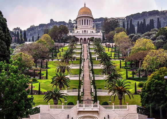
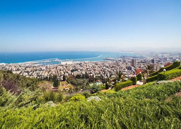
Right here below the hotel you'll find the gorgeous Louis Promenade, 400 meters that stretch across the mountain range above Yefeh Nof Street and offer panoramic vistas of Haifa, from the city to the bay, to the Krayot, Acco and Rosh Hanikra, the Galilee Mountains, and on a clear day, as far as Mount Hermon. From here you can also see the hanging Bahai Gardens which have earned a UNESCO World Heritage Site designation. The gardens link to the German Colony’s main road which then heads towards the port and the sea. These iconic vistas become the city of Haifa’s internationally recognized “identity card.”
The promenade, built in 1992, is considered one of Israel’s most beautiful. We’ll connect to it via a small lane that passes between the Tikotin Museum of Japanese Art and the Dan Carmel Hotel’s entrance plaza. The path passes right under the hotel’s renowned Rondo Restaurant. The end of the promenade brings us to a small grove planted by the Templers, and known as “Emperor’s Grove.” Here the Templers positioned a stone obelisk on which the names of Emperor Wilhelm II and his wife Augusta Victoria are engraved, commemorating their visit to the colony at the start of their journey in the Land of Israel in 1898. Next to the obelisk is a Belgian maritime cannon from the mid-19th century, in use on French and Turkish warships. We recommend a short walk through the gardens adjacent to the promenade. Commonly known as “the fawn garden” for the sculpture of the fawn drinking from a pond, and additionally known as “Yefeh Nof” Garden, the pond and waterfall were planned by the architect Shmuel Rozov, who also planned the Dan Carmel Hotel. The fawn was produced by sculptor Arieh Resnik.
Let’s continue to the next location, the Sculpture Garden, which is some 10 minutes’ walk away. We leave the promenade for Yefeh Nof Street and walk west. Down the street’s slope we connect with Hanassi Boulevard where we turn right. A short walk brings us to Hatzionut Avenue, where we cross the road and continue down Hatzionut Ave. Next to house number 110 we find the entrance to the Ursula Malbin Sculpture Garden. It is one of the most enchanting and special spots in Haifa, a green oasis that leaves the bustling street far behind, and overlooks the blue bay. Scattered across the garden are 29 delicate bronze sculptures donated by sculptor.
Now let’s go back to Hatzionut Avenue and continue to our next stop, the Bahai Gardens. Entrance is free. Enter from 80 Hatzionut Avenue, the main entrance, which leads you straight to the main Bahai Garden area, the shrine, and the surrounding gardens which UNESCO, in 2008, declared a World Heritage Site. The Gardens are a system of 19 terraces built in stages across some four decades, between the 1950s to the 1990s. The shrine preserves the remains of the Bahai Prophet, known as the Bab, who first spread the concept of the Bahai faith in the mid-19th century in Persia. The Bab’s heir, known as Baha-Ullah and viewed as the faith’s founder, is buried in Acco but the Haifa gardens, which constitute the Bahai World Center, have become the holiest site to the Bahai adherents. Baha-Ullah’s son, Abas Effendi, known as Abdul-Baha, carried the community’s management and leadership until his death in Haifa in 1921, following which he was buried alongside the Bab in another room of the shrine on the Carmel Mountain.
Currently the Bahai community worldwide is run by a commission of 9 persons who operate from a holy temple complex built on the mountain adjacent to the shrine and other structures.
Entering the shrine requires modest dress and bare feet. Photography inside the shrine is prohibited. Eating, smoking and chewing gum are prohibited everywhere in the gardens but bottles of water can be brought in.
Insert image
Independent visits: We recommend checking the Bahai website for visit times: https://www.ganbahai.org.il/self-guided-visits The Bahai Gardens are closed on Bahai holy days and Yom Kippur.
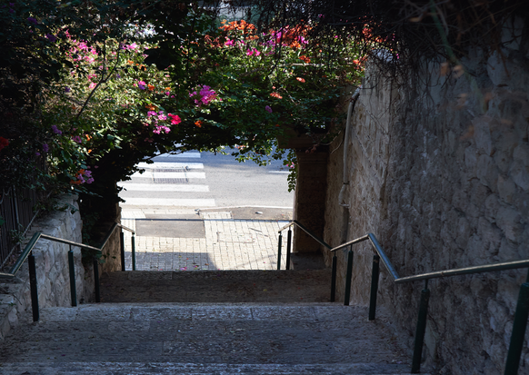
Our visit to the Bahai Gardens over, we’re now ready to continue on to the German Colony. Leaving the gardens, turn left and head down Hatzionut Avenue, then left again into Shifra Street. Here we integrate into the Haifa stairs which drop down the Carmel Mountain’s side to the Lower City. At the end of Shifra Street we go down the Shifra Steps into Abbas Street, turn left, then continue to go down the Kramim Steps into Geffen Street. There we turn left and reach UNESCO Square. Facing us is Sderot Ben Gurion which goes all the way to the sea. This is the German Colony’s main road. The German Colony in Haifa was built by the Templers, members of a Christian Protestant pietist sect founded in Wurttemberg, Germany. According to their belief, bringing the redemption about an only occur by living and working hard in the Holy Land. They sought to uphold an idealistic lifestyle by establishing productive villages in the Land of Israel.
The best way to start a tour of the German Colony is to head for the Haifa Tourist Association branch at 48 Rothschild Boulevard. A city of Haifa Information Center operates there, where you'll be able to get more detailed information and a map of the colony. In recent years the German Colony underwent renovations and preservation activities that made it one of the liveliest and unique entertainment and leisure spots in Haifa.
Using street signage you'll be able to enjoy the heritage preservation efforts on dozens of Templer homes along the boulevard, including the Oliphant House, Schumacher House, the Templer Community House, and more.
Go for a stroll through the Colony and learn about the Templers’ long history in Israel, take a peek into the gardens and courtyards, enjoy the atmosphere of the preserved buildings, and stop for a coffee or bite to eat from the many choices available.
Our urban trek has almost come to an end. We recommended planning it so that you have enough time to also take in the Haifa City Museum, opened in 2000 in the Beit Ha'am [Community Center] buildings and the Templer School buildings at 11 Sderot Ben Gurion. Documenting the city’s history, it is open: Sunday 10 am - 4 pm, Wednesday 10 am - 4 pm, Thursday 12 midday - 8 pm, Friday 10 am - 2 pm, and Saturday 10 am - 4 pm.
THE HEART OF HAIFA: One Thousand Stairs
Let’s go for an urban tour of Haifa’s beating heart, into the Hadar neighborhood. This is an urban tour that’s great for people who love to take a peek at quiet streets and hidden spots across the city which carry the nostalgic memories of the city’s glory days. This urban tour presents authentic Haifa, important and beautiful structures in the city built in the international Bauhaus style of the 1930s. Our walk down the Carmel’s slope lets us encounter this uniquely Haifa aspect of the city. We go through the heart of the Hadar neighborhood and come across countless small and larger stepped paths that link Hadar’s streets. When we come to Massada Street, picturesque and the neighborhood’s center, we can see how, over recent years, it’s become a kind of Soho. We’ll walk along historic Herzl Street and end near the long-time Talpiot Market.
The Steps Tour
Let’s leave the hotel and go south along Hanassi Boulevard. Turning left, we enter Shaar Halevanon Street, which takes us to Yefeh Nof Street, where we turn right and walk some 100 meters up to the sign “Gedera Stairs.” This is where Haifa’s four routes of 1000 stairs begin.
Ancient Haifa was built on the bay’s southern area adjacent to the current location of Rambam Hospital. In 1761, Dahel al-Umar, the governor of the Galilee, destroyed the city and rebuilt it. As the city expanded, new neighborhoods were established further up the mountainside. Over time the stairs connected the lower city to the neighborhoods and the Carmel Mountain, and especially, the main route used by residents.
Let’s go down the Gedera Stairs leading into Henrietta Szold Street, cross the road, and continue to go down as far as Hashmonaim Street. There we take a right and connect to Tuvia Dunya Stairs. Tuvia Dunya was an engineer and founder of the Hadar neighborhood, and among the builders of YMCA Jerusalem.
A short way down, we continue onto the path rather than stairs. The path ends in a T junction where we turn left and rising to a small garden with playground apparatus at the top of Spinoza Stairs. These steps, surrounded by trees, are among Haifa’s prettiest. Where they meet Bar Giora Street, turn right and you'll reach the “Glass House” at 21 Bar Giora Street. This is considered one of the city’s most important and stunning examples of Bauhaus style, planned in 1938 by the architect Theodore Manx as an apartment block. Built around a U shape, its center contains a swimming pool, and a tennis court is located on the roof!
We continue our trek down the stairs found to the left of 15 Bar Giora, known as Haemek Stairs. Let’s go down all the way to where they meet Masada Street, in the Hadar neighborhood’s heart.
Hadar neighborhood is one of Haifa’s oldest, and a central residential quarter in the city. Established as a “garden city” based on Richard Kaufman’s 1922 plans, its commercial hub is located on Herzl and Hehalutz Streets, but other small picturesque side streets literally throb with cafés and shops that attract the younger crowd while maintaining the unique flavor of a village. The same is true of Masada Street, along which are small boutiques, second hand stores, records, vintage and retro shops and bookshops in a surrounding covered by colorful graffiti artwork that fills the street. You might like a short break at one of the cafés before we go further.
From Masada Street, we’ll continue down Kassel Steps and connect to Shmaryahu Levin Street, with its beautiful historic buildings from Hadar’s glory days. Beit Atin on the corner of Kassel and 30 Shmaryahu Levin was built in the 1920s for Yehuda Atin and his family by engineer and architect, and fellow Haifa resident, Gedalyahu Wilbushewitz.
Atin House is a stone structure in an eclectic style. Its two sections are linked by a small corner tower that makes the house seem like a castle. The home served the family only briefly, soon becoming Hadassah Hospital, and later belonging to the Rothschilds. From 2017 on it serves as the “Hiyar” Democratic School, a private organization and the only one of its kind in the Arab sector. Adjacent to the school is the Haifa Elementary School, also occupying a beautiful 1920s structure. But the jewel in the architectural crown, and perhaps one of the most attractive in all Haifa, and definitely on our brief tour, is the Technion structure nearby. Right opposite Atin House you'll find the entrance to the Technion (see the brown sign, “Madatech”). Let’s walk south towards Jerusalem Street to the building’s southern flank. When walking from Shmaryahu Levin Street to Jerusalem Street, we discover the impressive, if not glorious, facade of the building serving as the Madatech Museum. The Technion, being how Bialik coined the name from the outset, opened in 1924. It was planned by the architect Alexander Berwald, who sought to infuse a public and official spirit into the structure by using symmetry and monumentalism relative to the building’s surroundings, much like the Gymnasium School built in the same period in Tel Aviv.
Now we’ll walk south along Jerusalem Street to house number 13 and go down the Hillel Yafeh Steps. Jerusalem Street used to be considered one of the most prestigious, where many of Haifa’s elite used to live, among them Abba Houshi, Haifa’s legendary mayor who lived at number 15. The steps cross Nordau Street and eventually reach Herzl Street, bustling with commercial life at the neighborhood’s center. Herzl Street contains numerous historical buildings, such as number 16, which is the elementary school, opened in 1913 and was also planned by Berwald. Right opposite the steps is the historic Bauhaus style building painted red. It served as the Ora Cinema, built in 1935 and operated continuously until the 1990s.
Now we’ll go to our last stop in our urban tour: the Talpiot Market. Let’s continue walking south on Herzl Street and turn left onto Yehiehli Street, cross Hehalutz Street, and reach Sirkin Street where we make a right… right into the market! This market preserves the unique authenticity of open air markets and has been used by Haifa residents and the neighborhood for more than 80 years! At 35 Sirkin Street we find the roofed Talpiot Market structure which began operations in 1940. The building is of the Bauhaus style, planned by architect Moshe Gerstel. In the early 1990s, the market began showing serious slowdowns, but in 2020 renovations started to restore it to life as part of the municipal strategy of urban renewal for the entire Sirkin neighborhood.
Well, that’s it for now. We recommend heading back to the hotel by using the Carmelit subway. Go back to Herzl Street and walk north as far as Masaryk Square, which is about 10 minutes. There you'll find the Carmelit stations which will take you back to Gan Ha'em which is adjacent to the hotel.
From the seashore to the peak of the Carmel Mountains: The charm and romance of Haifa
Bat Galim Boulevard
Let’s leave the hotel and turn right onto Hanassi Boulevard to the bus stop adjacent to the corner of Dafna Street and 73 Hanassi Boulevard. Take the 31 bus heading for the Bat Galim neighborhood (the 136 line is also possible). After a ride of some 25 minutes, get off at the last station, called “Hahagana / Yoav.” We will walk westwards into the Bat Galim neighborhood via Rahaf Street, which brings us to the neighborhood’s main street, “HaAliya HaShniya.” Let’s turn right and reach the square where HaAliya HaShniya meets Bat Galim Boulevard which leads to the sea and is the starting point of our walk.
The source of the neighborhood’s name is in Isaiah 10:30, which says “Call out, Bat Galim.” Bat Galim’s literal meaning is “Daughter of the Waves.” Bat Galim is one of the veteran core neighborhoods of the Hebrew speaking areas of Haifa. Its uniqueness is in it being one of the few neighborhoods in Israel where homes truly sit on the waterfront. The neighborhood was planned by the architect Richard Kaufman in 1921. Kaufman planned several of Haifa’s neighborhoods over the course of the 1920s: Neveh ShaAnan, Hadar Hacarmel, Ahuza, and others.
At the corner of Yonatan Street and Bat Galim Boulevard a beautiful Bauhaus building overlooks the square, built in 1937 by Moshe and Dina Cohen, offspring of the founders of Zichron Yakov. The building served, among other functions, as a café and even a billiards club where British soldiers would go to relax. Currently it is a boutique hotel.
Let’s continue our walk and stop at number 10.
Samsonov House
One of the beautiful buildings along the boulevard, in the past it served the renowned veterinarian Dr. Yitzhak Samsonov. The building has an eclectic architectural style, giving it the appearance of a castle. In fact, it is a composite of three buildings. Two were built by the architect Barsky, who also planned the “Herzliya Gymnasia” school in Tel Aviv. Among Samsonov House residents were Sh.Y. Agnon’s family, forced to flee when the house was razed during the 1929 riots.
At 7 Bat Galim Boulevard we find another Bauhaus building originally owned by Yakov Caspi, for whom one of the neighborhood’s streets is also named. The home was planned in 1935 by the architect Alfred Goldberger, who also planned the casino at the end of the street.
The Casino
As noted above, this structure was planned in 1935 and was designated as a place for community leisure activities. Part of the original flooring was made of clear glass through which the waves could be seen. The building has variously housed a restaurant, café and dance floor facing the sea. On its northern side an Olympic size pool was built. The original structure collapsed during restoration works. The concrete skeleton currently standing there is a haphazard outcome following the collapse.
Bat Galim Promenade
The promenade was built on an area where the sea was dredged and dried out. Previously it had been a sandy shore. Along its length is a row of homes, the dominant among them being at 39 Margolin Quay. It is one of Bat Galim’s first ever homes, built in 1923 for Rabbi Moshe Hamawi, one of the neighborhood’s founders. Above the entrance balcony note the gables where you'll find a shell shaped stone engraved with the year of the home’s establishment and the verse “If I forget you, O Jerusalem, let my right hand forget its skill.”
Museum of the Navy and Immigration
At the promenade’s end, right next to the cable car station, we see a stairway, long, and circling upwards. It brings us from the promenade to a bridge that passes above busy HaHagana Boulevard. After we reach the top, cross the road and leave the bridge via the “Dakar Steps” which take us straight to the museum’s entrance. There we find the bridge of the Dakar submarine, pulled out of the sea depths where it had been sunk. In addition to the exhibition area inside, you can wander the museum’s vast courtyard and take a look inside boats that brought immigrants into the Land of Israel. You can also peek into a real submarine, brought here in its entirety.
Elijah’s Cave
Let’s leave the museum and head back up and onto the bridge. Several sets of stairs lead us from there to Elijah’s Cave. According to tradition, the Prophet Elijah hid here when fleeing King Ahab. Some Jews slip notes into cracks in the cave walls. You're invited to sit and rest in the shade of the ancient ficus tree near the entrance and feel the sense of sanctity surrounding the area.
Cable Car
Next, we return to the cable car station on the beachfront promenade. Buy a return ticket and enjoy yourselves for a few minutes of stunning views at the peak of Mount Carmel facing the gorgeous seafront. The evergreen mountain meets the blue bay for a breathtaking vista.
The name “Stella Maris” means “sea star.” The structure adjacent to the lighthouse on the mountain’s peak served as the Pasha Abdallah’s summer home. The Pasha was the Ottoman Governor. Facing the base’s gate is the sculpture of Miriam: Stella Maris is one of the terms by which Maria is known.
Stella Maris Path – and stunning observation point
Now the time’s come for a short nature walk. From the Stella Maris ridge we set out on one of the most stunning of the Carmel’s vista paths. The path takes us to the white-domed chapel called “The Holy Heart” or “Holy Family.” The structure was originally intended to serve as a windmill for the monks there. It was later turned into the chapel belonging to the Carmelite Monastery. To the east we see the “Jacob’s Base” marker named for the man who fell here during the War of Independence. At the chapel’s feet are two British buildings from the WWII period.
The observation point here is considered one of Israel’s most beautiful. If it’s a day with clear vision, you'll be able to see the Hadera Power Station’s chimneys to the south, Rosh Hanikra to the north, and the Meron Mountain Range to the east. From here, we can continue down a set of over 200 steps, some of which are built and others hacked into the stone, and reach Elijah’s Cave.
The Carmelite Monastery
Having reached the end of our walk on the Stella Maris path, let’s go back to the peak and cross the road for a visit to the monastery. At its entrance is a monument marking the soldiers of Napoleon’s Army which, when withdrawing from Acco (Acre) in 1799 left several soldiers suffering from the plague behind at the monastery. In 1767 the monastery began constructions, and in 1836 was eventually inaugurated. The glorious church hall provides impressive murals and a small cave serves as a place of prayer and space to light candles.
Our tour is over. From here you can head back to the cable car and go down to the promenade and Bat Galim. If you time things well, you'll be able to reach the pastoral Bat Galim shore to catch the sunset.
URBAN NATURE TOUR: SI'AKH CREEK DOWN TO THE SEA
Path: marked black
Walking time along the creek: 2-4 hours
Length of route: 2 kilometers (1.2 miles)
Path mapping: Hacarmel 4
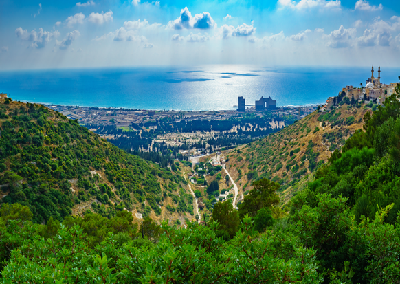
Down the slopes of the evergreen Carmel Mountain several channels flow, eventually spilling into the sea. The Carmel creeks are a vista unique to the city of Haifa, and offer access to stunning nature treks or easy walks from starting points right in the heart of the busiest streets. In a matter of moments, you enter an urban jungle completely disconnected from city life!
Nahal Siakh (Siakh Creek) is one of the most diverse and beautiful among the creek walks that Haifa has to offer, and suited to all ages. Along the way you'll come across the remains of an ancient crusader monastery, two clear water springs, caves in the rock, lime pits, a grove, and pond. And it all has an enchanting atmosphere of shaded Mediterranean groves, and landscapes that shift from rock faces to lookout points with beautiful sea views.
So get ready for a nature walk: there'll be plenty of water, you'll need comfortable strong shoes, hats, and sun cream. We recommend taking some snacks and/or some food for along the way, especially since there are numerous spots which are perfect for a picnic.
Let’s leave the hotel and turn left, walking south for about 12 minutes to our starting point. We’ll go up Hanassi Boulevard, which a few minutes’ walk later turns into Moriah Boulevard. Continue along Moriah for another 2 minutes, then turn right into Wolfson Street. About 100 meters along we reach Mina Square, where we turn left into Lotus Street. Walk on the street’s western side and some further 50 meters down we reach our starting point. Note the brown sign stating “Nahal Siach” (Siach Creek).
The creek was named for the poisonous shrub known as Wolf Milk (sometimes as Pencil Tree). This is the only habitat in Israel where it can be naturally found. As spring begins, the shrub becomes highly evident because of its yellow flowering, which in summer turns a red autumn hue. The creek begins in the Carmeliya neighborhood and ends adjacent to the Sdeh Eliyahu cemetery.
After following the creek for some 600 meters, we connect to another tributary of Nahal Siakh joining from the left. Right near where they join is a narrow path turning south which will take us to the remains of the ancient lime furnace. These are known to have been used in the Land of Israel from Biblical times. The furnace was kept burning for 3 days to a week with the thorny poterium plants which grow abundantly in the creek.
We continue on the path that runs along the creek’s southern flank, accompanied by stone terraces. Some 300 meters along we reach Ein Meshotetim, a small spring bubbling up from the cave and into a small stone pool. You can dip into the water in either of those spots. This is a great place for a short stop or a picnic, especially because of the cool flowing water and the shade of pomegranate trees nearby.
Facing the spring on the northern bank we find a cave from the crusader period, carved into the chalky rock. A door blocks entry. The cave was a place to isolate for prayer, a burial location, and even a storage area where monks from the nearby monastery would stock their goods.
The remains of the Carmelite Monastery are to the west of the Ein Meshotetim spring. To see them we’ll head down a few meters on the marked path. Before it goes down further into the creek we’ll take the southern bank and reach the monastery’s remains. Entry is not allowed because of the danger of the ancient structures collapsing.
Built by the Carmelite Order, a Catholic order established here on the Carmel Mountain in the 12th century, its residents were banished a century later but they returned another 4 centuries afterwards. Eventually the moved from here to the Carmel’s peak and are better known than their fellow monks at Stella Maris and Mukhraka. To the west of the ruins is a relatively new structure: a chapel. The location of the ruins affords us an excellent lookout point towards the sea.
On the northern point are chalky picturesque cliffs mingling with basalt rock. Above the northern bank and on the slope we can see the Kababir neighborhood, whose several thousand Muslim residents belong to the Ahmadiyya sect. This is their only location in Israel. Note the 300 stairs leading into the neighborhood. The Ahmadiyya teachings abhor violence and teach peace and love of fellow humans. According to their beliefs, the leader Ghulam Ahmed al-Qadiani, who began the movement in India, was Allah’s true Prophet.
Let’s now walk west. Here we see exposed chalk cliffs in which flint is embedded. This is a common phenomenon throughout Israel, especially in Rosh Hanikra and several sites in the Carmel Mountains. On this part of the trail, the Asian buttercup flowers early in Spring.
After a small drop down, we reach Ein Siach, or Siach Spring. It derives from the slope to the road’s right, and a short pipe lets its water flow into the ditch and a shallow pool. Next to the pool there’s a “grassy” area that’s actually an invasive feather-bristle species as well as sticky inula shrubs. When you reach the pool you'll be able to see the pipe carrying its cool clear water down from the mountain where it starts. Next to the pool we’ll find a path marked in red and leading to Nahal Ezov (Ezov Creek) which lets you take that almost circular walk back to the Carmel Ridge if you're interested.
Continue down the trail, westward. A short walk takes us to the next stop, Bustan Khaiyat. This grove was planted by the Christian Khaiyat family in the 1930s as a holiday spot. The grove is some 145 dunams (35 acres). Efforts are currently being invested to restore it and preserve its unique atmosphere. Here you can see the ponds and channels linking the grove’s various sections, the water coming from the Siach Spring. When the large pond seasonally fills, trekkers can enjoy a dip there.
A short walk from the grove will take us out of the creek and to “Shaar Brosh” (literally, Cyprus Gateway) at the entrance to the Sdeh Eliyahu Cemetery.
From here we can catch the bus (or call for a taxi) to take us back to Hanassi Boulevard. The line 3 bus will bring you to the Carmel center and the corners of Yitzhak Elhanan Street and Hanassi, from where you'll walk about 10 minutes down Hanassi to return to the hotel.