
Jerusalem Attractions
Considered to be the most abundant area of interesting sites and things to do, you will find a variety of attractions for every age and every season in Jerusalem.
Apart from the holy sites of the three religions, the capital of Israel includes some of the most famous points of interest in the country.
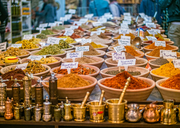
The attractions in Jerusalem are fascinating and varied so you won't even have a minute to spare - starting with the Biblical zoo and the Israel Aquarium adjacent to it, through to the City of David site located near the Western Wall and strolling the alleys of the Mahane Yehuda market with its many colorful booths, cafes and authentic restaurants.
On this page we have collected for you the must-see attractions in Jerusalem, special attractions for children, special tours, museums and all the things you must do in Israel's capital city.
Local Attractions
JERUSALEM: THE FIRST NEIGHBORHOODS OUTSIDE THE OLD CITY WALLS A circular walk: starting and ending at Jaffa Gate (Sha’ar Yafo)
Let’s set out on a historic walk through Jerusalem’s first neighborhoods. This walking tour will take you into the heart of Jerusalem, and the first neighborhoods constructed outside the Old City’s walls, as well as famous historic sites.
Let’s cross the Shaar Yafo plaza above busy Yafo Street and enter the Mamilla Mall, a boulevard of shops linking Shaar Yafo with Agron Street.
We pass by Stern House at 18 Mamilla. This is where Theodore Herzl stayed for several days during his 1898 visit to Jerusalem. One of the rooms here presents a small exhibition perpetuating Herzl’s tour of the Land of Israel.
Mahane Yisrael. Leaving Mamilla Mall, take a look at the magnificent structure standing on the corner of Agron and King David Streets. This is the Waldorf Astoria Hotel, built where the historic Palace Hotel had been but preserving the Palace’s facade. To the right of the hotel’s front facing Agron Street, we enter the Hamaaravim Street, which is the neighborhood’s main road.
Mahane Yisrael is the second neighborhood built outside the Old City’s walls, Mishkenot Sha’ananim being the first. Mahane Yisrael initially comprised 20 homes at its establishment in 1866, and housed Moroccan Jews who were living inside the Old City walls. Entering Maaravim Street puts us right into e small, picturesque neighborhood’s atmosphere. A very narrow lane at the end links us to “The David Amar Worldwide North Africa Jewish Heritage Center” with the beautiful Andalusian courtyard, which we warmly recommend visiting. Now let’s leave this neighborhood and return to King David Street, walk up the road, and encounter two of the city’s most important structures: the YMCA and right opposite it, King David Hotel.
Built in 1933, the YMCA’s two wings are linked by a 50 meter long bell tower containing 36 bells. At the reception desk ask to use the elevator to the observation balcony above the bells. This gives you a wonderful panoramic view of the entire city.
Now we’ll cross the road and turn out attention to the King David Hotel. It began operations in 1930 and has known numerous events in its lifetime, the most renowned among them being the 1946 explosion of its southern wing by members of the Etzel movement. We recommend entering the stunning lobby and taking a look at the building’s parts, which now house a hotel of 9 floors containing 237 rooms, including the Presidential Suite and the Royal Suite.
Leaving the hotel, we turn left and walk south along King David Street. Right after the apartment building adjacent to the hotel is a narrow lane turning left and leading into Blumenfeld Garden. The eastern flank of this well-groomed space takes us to two of Jerusalem’s most famous neighborhoods” Yemin Moshe, established in 1890, and Mishkenot Sha’ananim, established in 1860. The latter, as already noted, was the first neighborhood built outside the Old City.
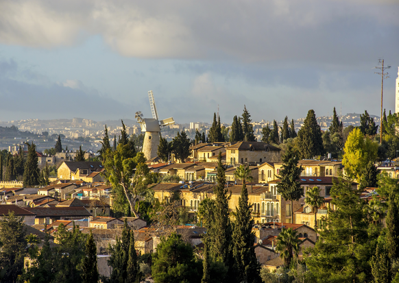
A short walk in the garden will lead us to the Mishkenot Sha’ananim Windmill. The mill was the first structure built in the neighborhood by Moses Montefiori, in 1858. The mill’s dome was later rehabilitated and its original appearance restored. Adjacent is Montefiori’s carriage. These days an experiential activity operates there, called “The Windmill.” The mill was an important structure for people involved in renewing Jewish settlement outside the Old City walls. It is now a dominant monument in modern Jerusalem’s urban landscape.
Now let’s go down the steps into Yemin Moshe Street. This street separates two neighborhoods: Yemin Moshe to the left, and Mishkenot Sha’ananim to the right. At the corner of Yehuda Tura Street, turn right. Here a small building stands: it is one of two focal structures in Mishkenot Sha’ananim. The large one was built in 1860, the smaller one in 1865. To the right of the smaller building we find a structure containing 4 toilet stalls in its original form.
Let’s now go down the stairs, passing by Malchi Street on the left, and turn right into a small street that stretches along the face of the large building at the neighborhood’s entrance gate. There we can stop and look at the building, which contained 20 apartments, each being 1.5 rooms in size. Most of these apartments were divided equally among Sefardi and Ashkenazi Jews. The top of the building displays a dedication to Yehuda Tura, a wealthy Jew from New Orleans who contributed the funds, and to Moshe Montefiori, who initiated and executed the idea to establish these residential units. The neighborhood’s name derives from the verse in Isaiah (32:18): “And my people shall abide in a peaceable habitation, and in secure dwellings, and in quiet resting-places.” Next to the gate were water wells. The gate is the only residue of the serrated wall that surrounded the entire neighborhood. Currently the building serves as a hotel for Jerusalem Municipality guests, particularly writers and intellectuals.
Now let’s turn left and leave through Mishkenot Sha’ananim’s exterior gate, accessing an asphalted road named Sh.A. Nakhon Street. Turn left again and walk along the lower border of the Yemin Moshe neighborhood, with Sultan’s Pool to our right, until we reach Yemin Moshe’s gateway. Walk through the alleys, and head north. During the War of Independence (1948) and the Six Day War (1967), this neighborhood was right on the Jordanian border. Starting in 1970, the neighborhood began undergoing restoration and renovation, turning into an artists’ quarter. Continue from Nakhon Street into Dror Eliel Street with a slight turn to the right. Further up Dror Eliel and again slightly off toe the right is Felt Street, which brings you to the Hutzot Hayotzer Artists’ Colony, with its studios and galleries and a small Visitors’ Center commemorating the activities of legendary and long-time Jerusalem mayor Teddy Kollek. At Hutzot Hayotzer’s eastern end you'll find a monument. There, make a left and a short walk later on the road’s edge, skirting the Old City walls, we can enter Teddy Park.
Teddy Park was inaugurated in 2013. It integrates walls commemorating Teddy Kollek’s activities, and attractions for visitors, such as a water jets platform, a sophisticated sun dial, and the “Jerusalem at the Center of the World” sculpture. Behind the water jets platform are historical structures, remnants of a forgotten neighborhood from the period of “exiting beyond the walls.” This is the Ja’urat al-Inab (literally: The Jujube Den) neighborhood, established by Jews from North Africa, but which gradually turned into an Arab neighborhood until it was abandoned in the War of Independence. From the park we can now head back to Shaar Yafo (Jaffa Gate), our end point.
NAHLA’OT AND SHUK MAHANEH YEHUDA: ENCHANTING JERUSALEM
We’re setting out on a walk through the beating heart of Jerusalem. We’ll wander through the enchanting alleys of Nahlaot, we’ll discover the unique aromas and flavors, sounds and atmosphere of Jerusalem. Here in these old narrow streets, among the stalls crammed against each other in the shuq, the open and closed market, and the ever busy Yafo Street, a new Jerusalem was born, one based on charm and longing. This is a surprising walk, which brings us face to face with communities and cultures of differing styles and ways of life. If a picture paints a thousand words, Jerusalem is indeed that picture, with a thousand faces and facets. This is a unique opportunity for all who love the city, and wish to understand a touch of what drives it. So let’s set out and see what makes this city so unique.
We start our tour with a ride on the light rail. It’s a great way to discover the city of Jerusalem’s different part, and Jerusalem is spread across a huge area. We recommend that you don’t forego that opportunity! Here, along the length of Yafo Street, which was so called because it led from the walled Old City all the way to the Yafo (Jaffa) port, 31 neighborhoods were established towards the end of the 19th century. Collectively they were known as “Nahla’ot.”
The first of these was Even Yisrael, established in 1875.
Nahlaot
We pass the eclectic Borochoff House at 64 Yafo Street, and cross the road, then turn left into Mashiach Borochoff Lane. Turn left again and a narrow lane takes us into a closed courtyard. This is the Even Yisrael neighborhood, established as noted in 1875. This is a typical courtyard focused neighborhood, surrounded by 53 homes which create a kind of central communal area, with lands leading to it. A large iron gate would be closed at night.
Now let’s leave and step into Agripas Street at number 23. There we pass under an archway into the tiny Sukkat Shalom neighborhood, established in 1881 and where Eliezer ben Yehuda and Yossef Navon lived. Cross the courtyard and turn right into Mishkenot Yisrael Street, and then left into Berab Street. This was the center of Mishkenot Yisrael, established in 1875 and at the heart of which we find the Beit Avraham Synagogue, the first to be built in Nahlaot. In the courtyard you can still see the neighborhood water cistern.
Let’s go left into a narrow lane called Abulafia Street, and all the way to Rabbi Aryeh Levin Street. This is where Rabbi Levin lived. He was known as ‘father of the prisoners’ for accompanying the underground’s prisoners led to the gallows.
Now we’ll move on to the end of Abulafia Street, and see the remains of the cistern that served the small “Batei Gorall” neighborhood. Literally meaning “lottery houses,” the name derives from the lottery by which the houses were allocated. There were 12 homes, and the Gorall Synagogue which continues to operate to this day! The neighborhood was established specifically for 12 Jewish families of Yemenite origin.
Now we trace our path back to Abulafia Street and go left into Levin Street, then cross Shomron Street and enter the Mazkeret Mosher neighborhood built in 1885. Make a right in Shirizeli Street into Carmel Street. Facing us we see the arched entrance that leads from Agripas Street into the neighborhood. We pass under the arch and take a peek at the entrance side on the Agripas side. The sign commemorates Moshe (Moses) Montefiore, for whom the neighborhood is named.
Back to Carmel Street, we continue along it into the Ohel Moshe neighborhood at the heart of the famous “Mulberry Garden.” Yossi Banai, who lived here, memorialized the tree in his song, “Me and Simon and Little Moiseh.” Yitzhak Navon, Israel’s 5th President, wrote of the tree and life in the neighborhood in his play “Spanish Orchard.” The house at 11 Gilboa Street was where Navon grew up.
Let’s continue a few steps more down Gilboa and turn left into the lane connecting it to Ohel Moshe Street. At the street’s end we reach the neighborhood’s pretty synagogue: we recommend going inside. Next, we turn right and reach Mazkeret Moshe Street, which takes us back to Agripas Street. Pass Etz Haim and HaEgoz Lanes, which are the heart of the market, but we won't go in there just yet. Instead, we’ll continue west along Agripas. We pass Mahane Yehuda Street and continue down the street.
Walking through the streets around the market has us encounter important culinary institutions operating inside the market itself, such as the Mordoch restaurant on the corner of Agripas and HaArmonim Streets, or the Khatzot steakhouse, inventor of the “mixed Jerusalem grill” dish on the other side of the road. From Agripas, let’s turn right into Beit Yakov Street where we find the “Mahneyuda” restaurant. Now we turn right into Hashikma Street, and pass by the very first “Rami Levi Hashikma Marketing” store. On the corner of Eshkol Street we find “Rahamu” restaurant, possibly the most famous in the market which, over the years, has turned into a Jerusalem icon.
Let’s continue along Eshkol Street and connect to Mahane Yehuda Street. Here you can feel the market experience full-on. Turn right into Eliyahu Yakov Banai Street, and note the metalwork and a small sign noting “5683 – 1923 – Meir Eliyahu Banai.” Here is where the famous Banai family lived. At the end of Mahane Yehuda Street you enter the “Iraqi” market, where you'll find the renowned Azura restaurant. At the end of the lane you'll find the “Hamrot,” small cafés that serve coffee, tea and alcoholic drinks and appetizers.
Nightlife in the market is no less busy. It’s a fascinating place to be and so different from the daytime activities. Suddenly at night countless of the stalls turn into bars, pubs, eateries and cafés. The market’s alleys can sometimes be busier at night than during the day! The night scene is like one great big festival. Mahane Yehuda has, over the past few years, become a hotspot for entertainment and fun, and renowned throughout Israel, as well as one of the most iconic Jerusalem scenes. We warmly recommend coming back to visit at night!
Now we’ll go out to Yafo Street and look at number 92: “The Sundial House.” Built in 1908, the sundial was used to set prayer times. The two other dials served for winter times or cloudy days.
That’s it. Our walking tour is over. From here you can take the light rail and continue to other parts of the city, or head back to your hotel.
On Your Walls – City of David: The Wall Walk and the Old City
We’re setting out for a walk on the Old City Walls, and through the Jewish Quarter in the Old City of Jerusalem. This walk brings us to breathtaking vistas of ancient and modern Jerusalem, and to its holiest sites. Walking the walls is a one of its kind experience, and truly links to the longing for Jerusalem that we all hold in our hearts. This is an amazing walk with surprise after surprise, especially for those coming here for the first time.
- In preparation, we warmly recommend downloading the “Jerusalem Audio Tours” app containing more than 20 routes in the Old City area. The app is free, fun, and easy to operate but unfortunately is not available for iPhones.
- Note that entering the promenade on Saturday is possible by pre-purchasing tickets.
- This is a circular route that takes over 4 hours in total. We recommend you free up the entire day, although it is possible to do part, and continue with the rest later on.
- Wear a hat, and take water.
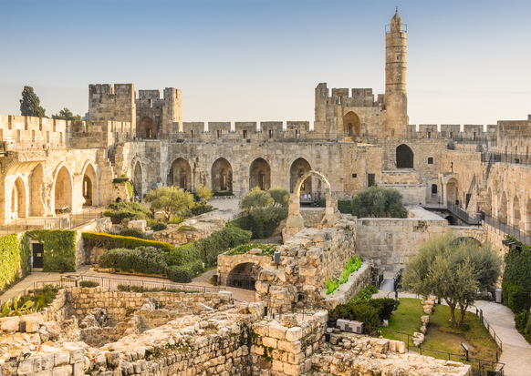
Let’s start in the plaza outside Sha’ar Yafo – Jaffa Gate. The promenade’s entrance is to the right of the gateway outside the walls, in the small entrance to the Migdal David – Tower of David museum. Buy your tickets (NIS. 20 for adults, NIS. 10 for kids), get the app ready, and let’s go. The Walls walk is easy and pleasant, and will take some 40 minutes depending on how long you stop at each spot.
The Jerusalem Walls have been recognized as a UNESCO World Heritage Site. It is the most dominant monument in the Old City, past and present. Built in the 16th century by Suleiman the Great, Sultan of the Ottoman Empire, it has stood steadfastly since then and to date.
Let’s now go up onto the walls and begin walking south. From the top we see western Jerusalem: the neighborhoods of Mamilla, Mishkenot Sha’ananim, Gai ben Hinnom (the Hinnom Valley), and Sultan’s Pool, the YMCA and the King David Hotel. To the wall’s right is David’s Citadel, the Armenian Quarter, various churches and monasteries, schools and courtyards, alleys, and the Jewish Quarter, Kidron Stream, Silwan, Har Habayit (The Temple Mount), and Har HaZeitim (Mt. Of Olives). It is a timeless mosaic that imbues Jerusalem with its uniqueness and interest.
The most dominant structure, which we can already see as we head upwards, is Migdal David, which in fact served as an Ottoman mosque’s minaret but over the years became one of the most famous city landmarks. We pass above the “Kishleh” campus, the former Turkish Army Base and detention center which became a police station and stable for police horses. Looking through the ramparts and firing slits reinforces the sense of strength and the perspective of the wall’s guards, who used this pathway for hundreds of years. We now pass above the Armenian Quarter’s homes and the wall turns east. To the right is the Abbey of the Dormition (from the word ‘sleep’). Tradition has it that Mary fell asleep forever here and rose to heaven.
Let’s continue to Sha’ar Tziyon – Zion Gate, also known as “the Jews’ Gate.” Note that above it there is a tiny balcony alcove to allow closely watching everyone entering and exiting the city. Here we end our Walls route and now descend into the gatehouse. Shaar Tziyon was conquered in the 1948 War of Independence by the Palmach fighters, and from here they broke through into the Jewish Quarter.
Enter via the gate into Habad Street, and walk north along the stone paved street with the large parking lot to your right. Let’s now turn right into Tifferet Yerushalayim Street and walk to its end. Then we’ll turn right again, take a few steps, and enter the roofed HaHatzotzrot Alley. As we exit the alley, we turn left and reach the monument set up to commemorate the Quarter’s fighters. Here 48 combat soldiers who died fighting to free the Jewish Quarter in 1948 are buried. Now we pass through Ma'amdot Yisrael Alley and reach a large plaza surrounded by buildings. This is Batei Mahseh Square: literally, ‘poorhouses square’. In the past, various poorhouses were found here. All have been demolished except for Rothschild House. In the 1948 War of Independence these poorhouses offered the last shred of protection to the Quarter’s combat soldiers who, gathered together in Rothschild House, eventually surrendered. Facing this structure we link to Misgav Ladach Street, walking north to Ma'alot Rabbi Yehuda Halevi Street where we turn right, then go down the steps leading to the Western Wall.
The Kotel - Western Wall or Wailing Wall - is the last remnant of the four support walls which surrounded the Temple Mount. It is some 488 meters long, and its original height was some 60 meters but currently the highest point is 40 meters. The wall is from 2 to 4 meters thick in different places. Built predominantly from heavy limestone, each block weighs from 2 to several hundred tons!! The largest stone is in the Western Wall Tunnels, and is 14 meters long!
After visiting the Kotel, let’s go back up into Maalot Yehuda Halevi Street and this time continue straight via the covered pathway facing us, Tifferet Yisrael Street, which leads us into the Quarter’s heart and Kikar HaHurvah or Hurva Square. Here we find two synagogues, Hurva, and Ramban, and alongside them is the now inactive Sidna Omar Mosque. We warmly recommend entering the synagogue and heading up to the observation balcony on its rooftop. Then go around the Hurva Synagogue from the left (its southern side) and in HaYehudim Street go down the steps and enter a small opening into the Cardo. You can identify the Cardo easily by the five pillars.
The Cardo, at some 23 meters wide, was the Roman’s “Aelia Capitolina” shopping mall. It is a stone paved boulevard lined by pillars and shops on both sides. Walking along this street takes us back over 2000 years. You might enjoy making some purchases in shops that are over 2 millenia old!
At the end of the Cardo we link up to the narrow market alleys. Keep walking straight through the perfumes market until you reach a T junction. Turn left there into David Street. This is one of the busiest market streets in the Old City, and will lead you all the way back up to Shaar Yafo – Jaffa Gate to end this tour.
THE CAPITAL’S CITY: FROM KHATULOT SQUARE TO THE X JUNCTION
This walk starts at “Khatulot Square,” the colloquial name for Maccabi Motsri Square. It’s located at the end of Jerusalem’s Nahalat Shiva neighborhood where Hillel, Yoel Moshe Salomon and Yossef Rivlin Streets intersect.
Nahalat Shiva was initiated by 7 ultra-Orthodox Jews in 1869. It was the third neighborhood built outside Jerusalem’s walls, the first two being Mishkenot Sha’ananim and Mahaneh Yisrael. Among Nahalat Shiva’s founders were Yossef Rivlin, Moshe Salamon, Yehoshua Yellin, and Beinish Salant.
Let’s enter the neighborhood via Salomon Street. In recent years this very old street underwent a facelift: facades of homes were preserved, and the street was turned into a lively pedestrian path and a modern shopping center. Before visiting the neighborhood itself, we recommend taking a left at house number 14. This is the “synagogues lane” which will take us to the picturesque and almost hidden courtyard known today as The Music Square. There you'll find restaurants, cafés and a stage for live performances. You can also visit the adjacent Museum of Italian Jewish Art. We also recommend a visit to the unique and special Museum of Music operating in number 12. It’s a real experience.
Now we’re ready to go into the neighborhood proper, which we’ll find sandwiched between two streets: on the west, Yoel Moshe Salomon, and on the east, Yossef Rivlin. At the start of Salomon Street we’ll turn into Haim Halevi Kovner Alley until we reach Maalot Nahalat Shiva Alley. Then we’ll make a left and walk through the lane. On our left we see Beinish Binyamin Salant Alley, further along we see Michel Cohen Square, and adjacent is Arieh Leib Horowitz Alley. All these were named for the neighborhood’s founders. After Michel Cohen Alley we see two synagogues. The one on the right is the Nahalat Yakov, which follows Ashkenazi custom and was the first synagogue in the neighborhood. On the left is the Sefardi custom synagogue, “Ohel Yitzhak.” After this synagogue, turn left into a pretty court with a water well. At the court’s furthest end is the “Tmol Shilshom” café and integrated bookstore. From the court we head into Yehoshua Yellin Alley back to Yoel Moshe Salomon Street. At the end of the street, turn left. It takes us to Kikar Tziyon (Zion Square).
Zion Square
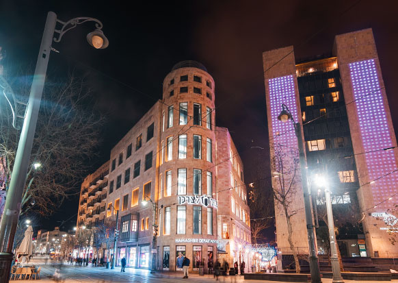
This is the most famous spot in the city’s heart. It’s located precisely where Yafo Street and the Ben Yehuda pedestrian mall intersect, and together with King George Street, form the center’s three main commercial streets. The square received its name from the mythological Zion Cinema which stood here from 1912 until its demolition in 1979. The square has known a great many historic events over the years, from public protests and demonstrations to terror attacks. It is primarily known for the massive protests held against the reparations agreements, the Black Panthers protests, and Oslo Accords protests, and more.
In the 1980s Ben Yehuda Street was turned into a pedestrian mall. In 2009, Yafo Street was closed to vehicles and now carries only the light rail and pedestrians. In recent years the square has become a hangout for young people, and a popular spot for municipal events and festivals.
Now we’ll walk up Ben Yehuda Midrahov (pedestrian Mall). It is the city’s beating heart, crowded by local shoppers and tourists most days of the year, but especially during Jewish festivals and holidays. Shops, bazaars, restaurants and street musicians give this walkway its special character of an ongoing happening. At the end of Ben Yehuda we turn left into King George Street.
At number 24, we find Froumine House, better known as “The Old Knesset.” Here the Knesset was temporarily housed from 1950-1960 and now being restored as a museum.
Adjacent to this is Gan Hasoos, or the Horse Garden. In the 1950s, the municipality planned to establish the Knesset building here, moving it from its nearby housing in Froumine House. Eventually, though, the land was turned into a public park, at the center of which stood the Knesset lamp, now positioned at the Knesset itself when the Knesset’s activities shifted into its permanent location. In 1997 a sculpture of a horse was placed in the garden. Known as the “Mare of Peace,” it lent its name to the garden, which is a small green lung with plants, and a small fountain. It’s very unusual in the typically urban landscape of its surroundings. You're invited to sit down and rest there for a few moments before we continue along King George Street. Currently the park houses a fascinating work known as “Dreams Coming True,” a sort of “palace” made of 550 window frames collected by artist Yoram Amir from abandoned or demolished structures throughout Jerusalem.
Now let’s go down King George towards Yafo Street again. King George V Street, commonly called very simply “Hamelekh George,” was inaugurated in 1924 on the completion of seven years during which the British military conquered Jerusalem, and was therefore named after King George V. The junction of Hamelekh George and Yafo was known in the past as the Tzomet X, or the X Junction, and is known to some degree for the many terror attacks carried out there or nearby, the most fatal being at Sbarro Restaurant on the corner. This is also the first junction in Jerusalem to have received traffic lights.
Let’s turn right into Yafo Street and walk towards Zion Square again. At the start of the 19th century, Yafo was Jerusalem’s main street outside the walled city, and its primary commercial center. Yafo, as it’s commonly called, crosses the city from east to west. It begins at Jaffa (Yafo) Gate in the Old City’s wall, goes through the city center up to the junction that exits Jerusalem. Several well-known squares and sites can be found along Yafo, including Tzahal Square, Safra Square (where the municipality office building is located), Zion Square, Davidka Square, Yafo-King George junction (“Tzomet ha'Iksim”), the new CBS (central bus station), and access roads to Ben Yehuda Pedestrian Mall and the Mahaneh Yehuda covered and open market.
Here our urban tour ends, right in the heart of Jerusalem’s entertainment and shopping center. This is the time to take a rest at one of the countless cafés along Yafo, which, once the light rail began operating fully, became Israel’s longest pedestrian mall.

Distance:
King David - 55 Km
Dan Panorama Jerusalem - 56 Km
Dan Boutique Jerusalem - 59 Km
Dan Jerusalem - 59 Km
We recommend to take a train from the airport to Yitzhak Navon station in Jerusalem from there you can take a bus, light rail or taxi to everywhere you wish in the city.